
Help from Afar
We talk with Shane Coughlan about a crowdsource project that gives drones a humanitarian purpose.
|

© Irina Matskevich - 123RF.com
We talk with Shane Coughlan about a crowdsource project that gives drones a humanitarian purpose.
These days, when you think of drones, you probably think of assassinations and police surveillance. However, the OpenRelief project [1] is developing a more humanitarian role for robot airplanes – gathering information to aid disaster relief. Using free software and off-the-shelf components, the project is well on its way to providing an effective toolkit at a fraction of the price of equivalent proprietary solutions.
OpenRelief came about when Shane Coughlan, the former Legal Coordinator for Free Software Foundation Europe, became involved in the post-tsunami recovery of Japan in March 2011. Coughlan recalls:
[We] were having quite a lot of trouble at the time knowing where precisely to send supplies and which people or groups in the rapidly evolving disaster zone were suitable contacts to help ensure effective distribution. This was far from a trivial issue, with cases of supply trucks being turned away from shelters due to lack of requirement or storage capacity, and other cases of breakdowns in the fairness of frontline distribution being reported. When you consider that we had just lost five hundred kilometers of coastline and we had hundreds of thousands of people in need it's not surprising, but it is something that needed addressing.
Coughlan continues with an example:
I recall a conversation with a team of triage doctors and NGO [non-governmental organization] workers as we prepared a daylong trip into the area north of Ishinomaki city. Someone asked if the village of Ogatsu Osu, a famous historical seaside location, was still there and if they needed supplies. We could not answer those questions with any of the available information sources, despite being less than fifty kilometers from the location. The only option for finding out if the village was still there was to drive towards it over unknown conditions.
Although Coughlan had always been interested in aviation, it had never been a major part of his working life. However, faced with problems like those he encountered in disaster relief, he realized that inexpensive drones were a practical solution. Together with Karl Lattimer, an English electronics and programming engineer, he began OpenRelief to create a solution.
The drones being developed by OpenRelief are about a meter and a half long (Figure 1) and can be launched from a very limited space – "from a footpath" is the description that Coughlan uses in a video on the project website. The drones carry sensors, whose readings are relayed back to mission control software and can be reprogrammed during flight. The result is a quick and safe way to gather information about the often-changing conditions in disaster areas.
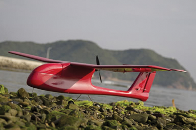 Figure 1: OpenRelief disaster drone.
The first prototypes use the ArduPilot Mega autopilot [2], as well as its firmware and mission control software, with a Raspberry Pi [3] main controller. The visual recognition software is OpenCV [4] running on Linux (Figure 2).
 © All figures © OpenRelief 2012; available under CC BY-SA 3.0Figure 2: An OpenCV mock-up of the kind of disaster information the OpenRelief project hopes their drones will provide: road status, danger levels, event sites, weather.
To this list of off-the-shelf components, OpenRelief is adding a ground-based radiation detector. According to Coughlan, this first detector will be the prototype for the development of other sensors. The hope is that others will contribute their own sensors, but OpenRelief itself will eventually develop an airborne sensor to add to the drones' monitoring capacity.
Another area for OpenRelief's immediate concern is coordination of all these parts – in Coughlan's phrase, to provide "the glue to tie these things together. The challenge is to expand existing software while keeping OpenRelief's own code as thin as possible." The present plan is to use a command-line tool called MAVproxy, developed by CanberraUAV [5], to coordinate interaction between the drones and mission control.
By using these pre-existing pieces of technology, OpenRelief can drastically reduce development time and costs. The first prototypes cost about US$ 750 each and, adding labor, could probably be built commercially for less than US$ 1,000. By contrast, Coughlan estimates, a similar proprietary solution would likely cost 10 times as much.
However, OpenRelief's development model can have problems. In particular, Coughlan mentions consistency of components as a problem. In one case, a supposedly metal gear servo melted, and, on dissection, turned out to be made partly of plastic.
"We are working through these issues now," Coughland says. "Part of our challenge in producing good outcome designs will be ensuring that references to material sources help people build reliable drones, sensors, and other tools for real-world use."
OpenRelief is only midway through its initial development, but already it is being noticed by other projects and companies. And, several companies, including Nanode [6] and Toradex AG [7], have contributed hardware to the project.
Additionally, the Sahana Software Foundation [8], one of the first free software solutions for disaster management, is helping make sure that OpenRelief's software is readable from its Eden disaster management platform. Similarly, OpenRelief is working with Cosm [9] to ensure its information can be shared across as wide a variety of hardware and software as possible.
Other connections are less obvious but open up intriguing possibilities. For example, Aleph Objects [10] has contributed 3D printing capacity, which opens up such possibilities as developing components cheaply, or even creating additional drones on the spot. OpenRelief is also working with OpenStreet Map Japan, not just to ensure compatibility of software, but also to re-map the existing disaster zone in Japan.
More recently, Lattimer has enlisted Eshott Airfield, a small facility in Northumbria for help in testing. As Coughlan explains, "This means that we can take prototypes to their airfield, test them in a safe location, and iron out bugs before we do a larger scale test. This type of access and capacity is a tremendous step forward, especially from the perspective of moving beyond off-the-shelf airframes and prototyping." Instead of just offering a theoretical solution, with such testing, OpenRelief can offer tested and proven ones – which should make other partnerships even more likely in the future.
Still another recent development is the donation of a conventional airframe design that has been released as open hardware [11].
"I believe this is the first time anyone has released an open source airframe," Coughlan says, "and it is an exciting platform to work on, not least because it has tremendous load capacity for its size (sub-two meters, up to nine kilograms of payload)."
These examples of cooperation suggest that OpenRelief's solutions are an idea whose time has come.
Pages: 4
US / Canada
UK / Australia

When you get back from a trip, you're usually bursting to tell everybody all about it and share your photos. Organizing your pics by location makes it easier to describe your adventures.

If you spend a lot of time writing, you need to concentrate on the essentials. With FocusWriter, you can work in full-screen mode with no disruptions.

The big news of the season is Microsoft cuddling up to Linux. But, how sincere is all this love really?

He performs drum 'n' bass live on Linux. Who's behind the neon knobs? We talk to OpenAV Productions founder Harry van Haaren about synths, stage performance, and a salary of 1.15 euros an hour.

What shines in the dark is often hidden by clouds. Stellarium provides a clear view of the stars plus a lot of astronomical data.